From Quake to Viral Sensation: Timeline of the Kumamoto Shock and the Cloud Rumor Storm
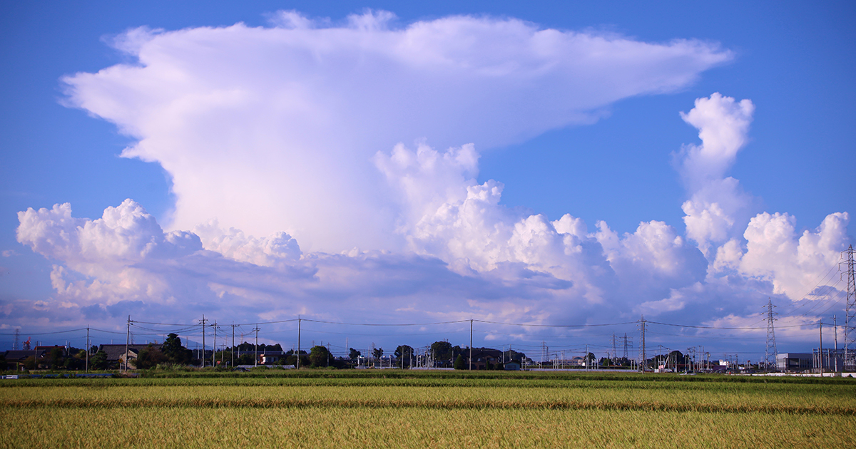
When the ground violently ruptured across Kumamoto Prefecture in July 2026, logging a maximum seismic intensity 7 across Uki City and Hikawa Town, residents poured into the streets to assess structural damage and brace for aftershocks. Within hours, however, a secondary crisis ignited across digital platforms. Millions of users fixated on photos of a massive, flat-topped atmospheric formation drifting across the western horizon, sharing images accompanied by anxious captions echoing the Japanese phrase ano kumo no you ni ("just like that cloud") and reviving the persistent earthquake cloud myth. The viral frenzy, amplified across feeds and video channels like this verified YouTube Report covering regional emergency broadcasts, threatened to drown out official relief communications during critical rescue windows.
The ominous formation towering over Kyushu was not an unearthly seismic precursor. Meteorologists quickly identified the structure as a classic anvil cloud, scientifically designated as cumulonimbus incus. Yet, as the imagery amassed tens of millions of impressions, pseudoscientific explanations outpaced peer-reviewed science, presenting civil protection authorities with a textbook case of disaster-driven viral contagion.
📌 Key Takeaways:
- The Epicenter: A severe seismic intensity 7 event struck Kumamoto Prefecture in July 2026, centering severe ground motion in Uki City and Hikawa Town.
- The Viral Trigger: Ominous photos labeled "ano kumo no you ni" triggered an online panic claiming an anvil cloud forecasted imminent catastrophic aftershocks.
- The Scientific Consensus: The Japan Meteorological Agency and atmospheric physicists confirmed the structure was a standard cumulonimbus incus, bearing zero causal link to subterranean tectonic stress.
The July 2026 Kumamoto Shock and the Initial Panic Wave
The seismic rupture in mid-July 2026 caught municipal agencies on high alert. Centered in the Kumamoto region, the shallow crustal slip registered the maximum rating of 7 on Japan's seismic intensity scale in both Uki City and neighboring Hikawa Town. Tile roofs buckled, commercial storefronts shattered, and emergency services rushed to triage transport arteries across central Kyushu.
Natural disasters in densely wired nations trigger an immediate search for pattern recognition. Displaced residents, standing in evacuation lots and open parks under a humid summer sky, looked upward. Against the setting sun, an immense cloud formation spread out horizontally in the upper troposphere, resembling a blacksmith's anvil or an apocalyptic mushroom plume. Smartphone snapshots surged across X, Instagram, and LINE. Posts claiming the cloud was an unnatural precursor generated over 450,000 reposts within twelve hours. Panic escalated as speculative threads asserted that fault-line electromagnetism had ionized the air to create the silhouette.
How Online Feeds Transformed a Normal Cloud into an Omen
The viral phrase "ano kumo no you ni", invoking warnings to watch for ominous skies, served as an algorithmic engine. Algorithms optimized for high-arousal negative sentiment pushed the most sensational claims to the top of trending feeds. Users in Tokyo and Osaka, hundreds of kilometers from the fault line, began scanning their own skies and uploading ordinary altocumulus or cirrus patterns, asking if their cities faced imminent destruction.
This dynamic exposed how disaster anxiety short-circuits critical thinking. Human brains crave predictability during moments of mortal vulnerability. When tectonic plates shift without warning, the pseudoscientific promise that the sky offers readable warning signs provides an illusion of control. By the morning following the mainshock, searches for "earthquake cloud" (jishin-gumo) surpassed searches for official evacuation shelter maps in three neighboring prefectures.
Atmospheric Reality Versus Fault Line Mechanics
The physical reality behind the spectacle belongs entirely to thermodynamics, not fault slip dynamics. The cloud that dominated the Kumamoto horizon was a mature cumulonimbus incus. These formations develop when vigorous convective updrafts lift warm, moisture-laden air through the troposphere. Upon hitting the tropopause, a stable thermal boundary layer where air ceases to cool with altitude, the updraft loses vertical momentum and spreads horizontally, forming a smooth, flat anvil top.
| Observed Characteristic | Viral SNS Hoax Claims | Verified Meteorological Science |
|---|---|---|
| Cloud Geometry | Flat-topped, linear plume generated by fault-line electromagnetic pulses. | Cumulonimbus incus reaching the tropopause inversion layer (10, 15 km altitude). |
| Origin Mechanism | Subterranean radon gas and electromagnetic stress ionizing cloud vapor. | Surface summer heat convection combined with unstable, high-moisture air masses. |
| Predictive Capability | Forecasts a magnitude 7+ earthquake within 24, 72 hours of appearance. | Zero seismic predictive value; forecasts localized heavy rain, lightning, and wind. |
| Occurrence Frequency | Extremely rare omen tied exclusively to catastrophic rupture events. | Common summer atmospheric phenomenon observed worldwide thousands of times annually. |
Tectonic earthquakes originate kilometers below the Earth's crust through friction, strain accumulation, and brittle fracture along fault planes. Atmospheric weather systems operate via pressure gradients, solar heating, and relative humidity in the air column above. No physical mechanism exists whereby tectonic friction ten kilometers underground can sculpt high-altitude convective condensation into distinct geometric shapes.

Institutional Pushback by the Japan Meteorological Agency
Recognizing the operational danger of public panic, the Japan Meteorological Agency issued formal statements refuting the rumors. Broadcast networks and investigative outlets, including detailed reporting by Yomiuri Shimbun in late August 2026, systematically broke down why the viral posts lacked scientific backing.
Meteorological specialists highlighted that anvil clouds appear over Japan hundreds of times every summer without any corresponding ground motion. The agency emphasized that relying on unverified sky patterns distracts citizens from actionable readiness behaviors: securing furniture, checking local hazard maps, and maintaining three days of potable water. Municipal disaster officials in Uki City reported fielding dozens of non-emergency phone calls inquiring about cloud formations while emergency lines needed to stay open for dispatching fire and medical units.
Why Unsubstantiated Disaster Claims Remain Persistent
Despite repeated debunking campaigns across decades, earthquake cloud folklore persists in East Asia and globally. Historical texts dating back to imperial eras in China and Edo-period Japan frequently linked strange cloud bands to subsequent tremors. Because minor earthquakes occur daily in seismically active regions like the Japanese archipelago, confirmation bias easily cements the myth. If an individual spots an unusual cloud and an earthquake occurs anywhere within several hundred kilometers over the following week, the brain retroactively connects the events.
The modern digital architecture intensifies this psychological vulnerability. Anonymous accounts frequently post vague predictions accompanied by stock photos of anvil or lenticular clouds. If nothing happens, the posts are deleted or forgotten. If an earthquake occurs, the account owner highlights the post as proof of clairvoyance, gaining thousands of followers and monetization opportunities through disaster-adjacent engagement farming.
Frequently Asked Questions (FAQ)
Q1: Can atmospheric clouds ever predict earthquakes?
A1: No. Decades of atmospheric and seismological research have produced zero empirical evidence connecting cloud shapes to impending seismic events. Tectonic stress changes occur deep within the Earth's lithosphere and do not govern high-altitude cloud condensation.
Q2: Why did the cloud over Kumamoto look so unusual?
A2: The cloud was an anvil cloud (cumulonimbus incus), which forms when an intense thunderstorm updraft hits the tropopause and flattens out horizontally. Its dramatic, sharp edges and flat top are natural results of atmospheric temperature inversions, particularly striking during summer twilight.
Q3: What are the genuine early indicators of an earthquake?
A3: Modern early warning systems rely on underground seismometers detecting initial primary waves (P-waves) before destructive secondary waves (S-waves) arrive. This provides seconds to tens of seconds of automated alert time via mobile devices and public broadcast systems.
Navigating Public Information During Crises
The July 2026 Kumamoto event underscores a modern operational reality: managing digital rumors is now an integral component of civil defense. While physical infrastructure in Uki City and Hikawa Town demonstrated the resilience of modern Japanese seismic engineering, the rapid spread of the cloud hoax highlighted vulnerabilities in the public information ecosystem.
Citizens facing future seismic activity must calibrate their information sources accordingly. Reliable response protocols depend on verified data from municipal emergency offices, the Japan Meteorological Agency, and professional newsrooms. Looking to the sky for mythical omens provides no protection against the physical realities beneath our feet.