Which Way Is Inbound on the Hokuriku Expressway? Fact-Checking Japan's Highway Terminus Rules

Rental cars and haulage rigs crossing Ishikawa Prefecture frequently encounter overhead highway displays warning of delays on either the Nobori (上り) or Kudari (下り) lanes. For drivers unfamiliar with Japan’s statutory numbering systems, deciphering which label points toward Kansai and which heads toward the Sea of Japan coast creates immediate uncertainty behind the wheel. The confusion surfaced on morning commutes following a vehicle breakdown between the Komatsu and Kaga interchanges, detailed in a 47NEWS Report documenting immediate closures along the corridor.
Under Japanese traffic law, expressway orientations do not change based on northern or southern geographical headings. Instead, they depend on an administrative starting post. On the Hokuriku Expressway (Route E8), the inbound direction (Nobori / 上り) runs toward Maibara Junction in Shiga Prefecture, while the outbound direction (Kudari / 下り) proceeds toward Niigata Chuo Junction.
📌 Key Takeaways:
- The Inbound Rule: Hokuriku Expressway inbound (*Nobori*) traffic always travels south and west toward Maibara Junction, feeding routes to Kyoto, Osaka, and Nagoya.
- The Outbound Rule: Outbound (*Kudari*) traffic heads northeast past Kanazawa and Toyama toward Niigata Chuo Junction.
- Administrative Anchor: Japan designates *Nobori* as movement toward a route's statutory origin point (0.0 kilometer mark), established where the corridor joins the broader national network.
The Maibara Anchor: Deciphering Nobori and Kudari on Route E8
The fundamental rule governing Japanese tollways relies on origin points (kiten) and terminal points (shūten). Every designated national expressway has an official starting point anchored in national transport ministry ordinances. Moving toward that origin point is classified as Nobori (ascending or inbound). Moving away from the origin toward the terminus is classified as Kudari (descending or outbound).
For the 476.5-kilometer Hokuriku Expressway, the administrative origin sits at Maibara Junction in Shiga Prefecture. The official terminus rests at Niigata Chuo Junction in Niigata Prefecture.
Drivers traveling through Ishikawa Prefecture toward Fukui, Kyoto, Osaka, or Nagoya travel on the Hokuriku Expressway inbound direction. Those heading north past Kanazawa, Toyama, Joetsu, and into Niigata drive the Niigata-bound outbound direction.
Because the expressway bends along the Sea of Japan coastline, magnetic compass directions often run counter to intuition. Between Kanazawa and Tsuruga, an inbound driver heads roughly southwest. Between Joetsu and Nagaoka, an outbound driver heads northeast. Relying on cardinal points like "northbound" or "southbound" creates errors; checking the administrative terminus printed on overhead signboards prevents wrong turns.
Why Japan Measures Highway Direction Against Terminus Rules
Expressway orientation terminology in Japan mirrors the historic railway convention established during the Meiji period. Early rail operators designated trains headed toward the imperial capital of Tokyo as Nobori and trains departing the capital as Kudari.
When the central government framed the National Expressway Act in the mid-twentieth century, planners adopted the same terminology for limited-access toll roads. Most radial arteries radiating outward from Tokyo, such as the Tomei, Chuo, and Kan-Etsu Expressways, place their zero-kilometer origin markers in or near the capital. For those routes, Nobori consistently means "heading toward Tokyo."
The Hokuriku Expressway does not touch Tokyo directly. Planners resolved regional connections by linking the Hokuriku coastal region back into the Meishin Expressway at Maibara. Because the Meishin connects the historic industrial belts of Kansai and Tokai, the Ministry of Construction established Maibara Junction as the zero-kilometer starting point. As a result:
- Kilometer Post 0.0: Placed directly at the Maibara Junction merge in Shiga Prefecture.
- Kilometer Post 476.5: Placed at Niigata Chuo Junction in Niigata Prefecture.
- Kilometer markers ascend as you drive toward Niigata, confirming outbound travel.
- Kilometer markers descend as you drive toward Maibara, confirming inbound travel.
Breakdowns and Collisions: Real Incidents on the Ishikawa Corridor
When road incidents halt traffic along Ishikawa Prefecture's industrial corridor, identifying the correct carriageway determines whether a freight driver diverts onto Route 8 or waits out the delay. Emergency maintenance managed by NEXCO Central Japan (NEXCO Chunippon) operates under strict directional labeling.
On July 1, 2026, mechanical failures disrupted transit on consecutive stretches. A disabled heavy vehicle triggered an inbound closure from Komatsu Interchange to Kaga Interchange, halting Maibara-bound commercial traffic until crews cleared the road at 11:15 AM. Simultaneously, an unrelated incident shut down the Katayamazu IC outbound lane between Kaga and Katayamazu for motorists traveling toward Niigata.
Misreading those directional indicators carried immediate consequences later that season. On September 8, 2026, an errant driver entered the expressway traveling in the wrong direction between Kaga IC and Katayamazu IC. The resulting three-vehicle collision shut down the outbound carriageway starting at 6:05 PM, backing up freight traffic for miles.
| Date & Time | Highway Section Involved | Direction & Heading | Disruption Cause |
|---|---|---|---|
| July 1, 2026 (Morning) | Komatsu IC, Kaga IC | Inbound (上り) / Maibara-bound | Commercial vehicle mechanical breakdown |
| July 1, 2026 (Morning) | Kaga IC, Katayamazu IC | Outbound (下り) / Niigata-bound | Disabled vehicle recovery operation |
| September 8, 2026 (18:05) | Kaga IC, Katayamazu IC | Outbound (下り) / Niigata-bound | Three-car crash involving wrong-way driver |
Drivers who understood that the outbound lane led to Niigata could bypass the September 8 crash by exiting at Kaga Interchange onto National Route 8, while Maibara-bound inbound traffic continued through Fukui without interruption.
How NEXCO Central Japan Displays Interchange Signals
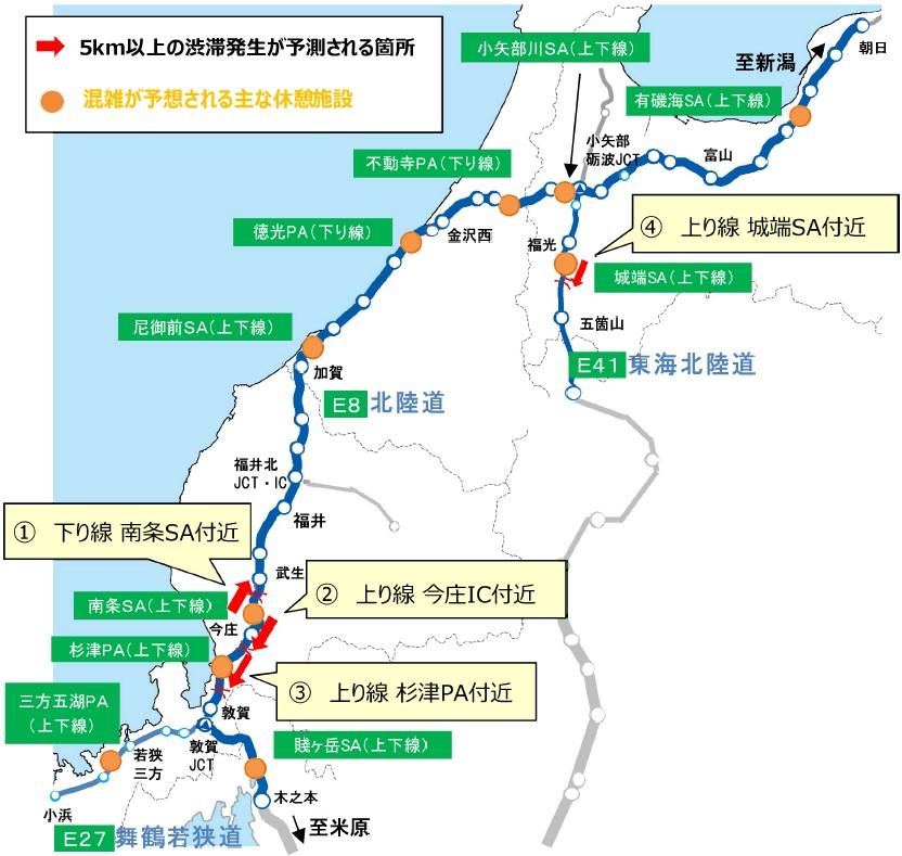
Road authorities recognize that international visitors and domestic tourists struggle with traditional terminology. NEXCO Central Japan, which operates the expressway from Maibara up to Asahi Interchange in Toyama, pairs kanji characters with landmark hubs on variable message signs.
Variable message signs suspended over toll plazas follow a consistent informational structure:
- Top Indicator: The line name and directional kanji (e.g., 北陸道 上り for Hokuriku Expwy Inbound).
- Anchor Destination: The major terminal junction in parentheses (e.g., 米原方面 for Maibara direction).
- Location Segment: The affected interchanges (e.g., 小松IC, 加賀IC).
- Current Status: The operational condition, such as 通行止 (Closed) or 渋滞 5km (Congestion 5 km).
On in-car navigation systems, English-language prompts frequently translate Nobori as "Bound for Maibara" or "Inbound" and Kudari as "Bound for Niigata" or "Outbound."
[Variable Message Board Display Example]
┌──────────────────────────────────────────────┐
│ 北陸道 上り (米原方面) │ <- Inbound / Toward Maibara
│ 小松IC → 加賀IC 通行止 │ <- Section Closed
└──────────────────────────────────────────────┘
┌──────────────────────────────────────────────┐
│ 北陸道 下り (新潟方面) │ <- Outbound / Toward Niigata
│ 加賀IC → 片山津IC 事故渋滞 4km │ <- 4km Accident Congestion
└──────────────────────────────────────────────┘
Paying attention to the green roadside kilometer markers offers another quick check. If the numbers on the median posts are decreasing, counting down from 150 toward 100, you are traveling inbound toward Maibara. If the numbers are rising toward 400, you are driving outbound toward Niigata.
Navigating Ishikawa Prefecture Tollways Without Wrong Turns
Navigating Ishikawa Prefecture's highway network requires tracking interchange splits closely around Kanazawa and Komatsu. Entering at major industrial ramps like Kaga, Awazu, or Kanazawa-Nishi presents two toll-gate slip roads immediately past the ticketing gantries.
┌── [左 / LEFT] ──> 上り (Inbound): Fukui, Maibara, Kyoto, Nagoya
[Toll Gantry] ──┤
└── [右 / RIGHT] ──> 下り (Outbound): Kanazawa, Toyama, Niigata
Drivers aiming for Kansai or the Tokai region must choose the ramp marked 上り / 米原方面 (Inbound / Toward Maibara). Choosing this lane directs vehicles past Awara Onsen, Fukui, Tsuruga, and directly to the Meishin interchange at Maibara.
Motorists heading north toward the Noto Peninsula, Toyama Bay, or Niigata must take the ramp marked 下り / 新潟方面 (Outbound / Toward Niigata).
If you take the wrong ramp, do not stop or attempt a U-turn on the slipway. Exit safely at the next interchange, pass through a manned toll booth lane, and notify the attendant that you entered by mistake (kanchigai). Toll operators will guide you through a turnaround lane behind the administrative office without assessing additional fees.
Frequently Asked Questions (FAQ)
Q1: Why isn't the Hokuriku Expressway inbound toward Tokyo?
A1: Japan's highway rules designate inbound (*Nobori*) movement toward the individual expressway's statutory origin point, not Tokyo itself. Because the Hokuriku Expressway originates at Maibara Junction in Shiga Prefecture and terminates at Niigata Chuo Junction, Maibara serves as the zero-kilometer anchor for all inbound traffic.
Q2: If I am driving from Kanazawa to Fukui, am I on the inbound or outbound lane?
A2: You are on the inbound (*Nobori*) lane. Driving south and west from Kanazawa toward Fukui takes you closer to the Maibara Junction starting point.
Q3: How do I know if an expressway closure affects my trip when reading roadside message signs?
A3: Look at the text inside the parentheses directly beneath the expressway name. If it shows 米原方面 (Toward Maibara), the alert applies to the inbound lane. If it reads 新潟方面 (Toward Niigata), the alert applies to the outbound lane.
Q4: Does the Hokuriku Expressway switch operational control between highway companies?
A4: Yes. NEXCO Central Japan manages the highway from Maibara Junction through Shiga, Fukui, Ishikawa, and western Toyama up to Asahi Interchange. From Asahi Interchange to Niigata Chuo Junction, management transfers to NEXCO East Japan (NEXCO Higashinippon). The inbound and outbound designations remain the same across both jurisdictions.
Reading Highway Logic Across Japan's Expressways
Highway route logic across Japan operates on legal definitions rather than compass headings. The system simplifies travel once the core rule is clear: Nobori points to origin, and Kudari leads to the terminus. On the Hokuriku Expressway, Maibara holds the zero-kilometer peg, setting inbound traffic firmly to the south and west. Recognizing that structure turns confusing overhead advisories into clear navigation cues, keeping you on the right carriageway regardless of sudden weather delays or interchange closures.