Can a Dead Typhoon Revive? The Science Behind Regaining Tropical Strength
Every late summer, millions of residents and travelers across Japan and East Asia enter the same urgent query into search engines: where is the storm, and is it heading our way? Late August brought sharp confusion to digital dashboards when chatter spread that Typhoon 18 had dissipated, only for subsequent alerts to warn of sudden re-intensification off the Pacific coast. As detailed in an investigative meteorological bulletin by the Yahoo!ニュース Report, regional forecasters had to unravel a volatile atmospheric clash between lingering tropical systems and shifting seasonal fronts.
The anxiety stems from a deceptive quirk of atmospheric physics. Storm systems frequently appear to vanish from digital radars when their organized circulation decouples, leading casual observers to assume the danger has passed. Yet a downgrading on paper rarely equates to safety on the ground. When warm oceanic energy meets shifting regional weather boundaries, a dying storm can transform into an unpredictable hydrologic engine.
⚡ Executive Summary:
- The Mechanics of Revival: Tropical systems do not literally resurrect from zero; remnant low redevelopment occurs when a disorganized vortex encounters high sea surface temperatures and low vertical wind shear.
- The Compound Threat: A weakened low can funnel massive subtropical moisture convergence into an existing front, creating catastrophic flooding hundreds of kilometers away from the original vortex.
- Verification Standards: Rumors on social media often misread wind thresholds as total storm death. Checking the official Japan Meteorological Agency forecast map provides verified track and precipitation data.
The Physics Behind Tropical Cyclone Regeneration
Tropical storms run on heat. They function as massive thermal heat engines, drawing sensible and latent heat from ocean waters above 26.5°C. When a storm makes landfall or encounters cool dry air, its cyclonic core fractures. The barometric pressure rises, central sustained winds fall below the gale-force threshold of 34 knots (17.2 m/s), and agencies formally downgrade the cyclone to a tropical depression or an extratropical remnant low.
That administrative downgrade does not erase the kinetic energy suspended in the mid-troposphere. If that circulating pocket of warm, moisture-laden air drifts back over deep thermal waters, such as the warm Kuroshio Current, while escaping disruptive vertical wind shear, tropical cyclone regeneration kicks into gear. Convection erupts anew around the vorticity center. The core warms, barometric pressure plummets, and the system re-establishes a symmetrical cyclonic wind field.
Atmospheric scientists refer to this process as secondary cyclogenesis or re-intensification. To the public monitoring a typhoon tracker in real time, the sudden reappearance of gale warnings looks like a phantom storm rising from the dead. In reality, the thermodynamic engine never fully stalled; it merely relocated to more fertile fuel grounds.
Dissecting Typhoon 18 and the Late-August Synoptic Clash
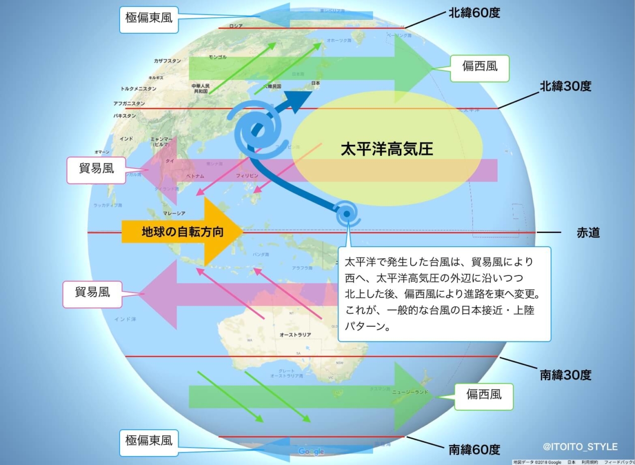
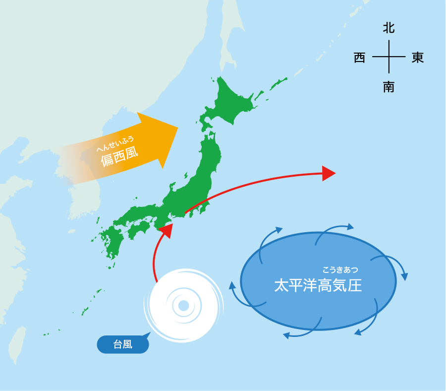
The late-August weather sequence illustrates the friction between meteorological definitions and real-world hazard levels. Forecasters tracked the system as it drifted northwards, but its journey was dictated by a rigid barrier: the western flank of the Pacific high pressure zone. This massive subtropical ridge blocked western progression, keeping regions from Tokai to Kyushu trapped under blistering, record-breaking temperatures exceeding 36°C.
Simultaneously, cooler continental air began edging south across northern Japan. As Typhoon 18 lost its symmetrical tropical structure, its remnant vortex did not dissolve quietly into the sea. Instead, the system hovered near critical maritime coordinates, sustained by anomalous ocean surface temperatures hovering between 28°C and 30°C.
This thermal reservoir prevented the cyclonic core from breaking apart entirely. Meteorologists tracking the storm track trajectory observed strong upper-level divergence pulling moist air upward, even as lower-level circulation appeared ragged. The storm straddled the line between an organized tropical depression and a revitalized coastal tempest, triggering urgent reassessments across coastal maritime corridors.
Tracking Dynamics: Tropical Depressions vs. Remnant Lows
Public confusion often originates in the technical vocabulary of meteorological alerts. A storm classified as a tropical depression still possesses dangerous convective squalls, while a remnant low undergoing extratropical transition can expand its gale field over a much broader geographic footprint than a compact typhoon.
| System Classification | Sustained Wind Speed Range | Core Energy Mechanism | Primary Public Hazard |
|---|---|---|---|
| Typhoon (JMA Standard) | ≥ 64 knots (≥ 33 m/s) | Latent heat release in warm core | Violent wind, storm surge, flash floods |
| Tropical Storm / Severe TS | 34, 63 knots (17, 32 m/s) | Organized tropical convection | Localized damaging wind, torrential downpours |
| Tropical Depression | Weakening warm-core vortex | Intense localized rain bands, landslide risk | |
| Regenerating Remnant Low | Variable (25, 50+ knots) | Hybrid baroclinic & latent heat | Widespread training rainbands, severe gales |
As the data shows, dropping below typhoon thresholds does not mean the atmosphere calms down. The danger shifts from concentrated central wind damage to expansive hydraulic deluges that stretch across several prefectures.
When Dissipation Deceives: Autumn Rain Front Interaction
The most dangerous scenario in late summer involves the autumn rain front interaction. Known locally in Japan as the akisame zensen, this stationary seasonal boundary marks the battleground where cold continental air from Siberia clashes with warm maritime air. When a dying storm drifts nearby, its cyclonic flow acts like a giant pump.
The system drags vast corridors of precipitable water out of the tropics. This subtropical moisture convergence slams directly into the stationary frontal boundary. The air is forced violently upward, triggering linear precipitation zones that drop 80 to 100 millimeters of rain per hour over areas that may be entirely outside the storm's gale zone.
Under these conditions, a downgrading notice from a weather bureau can inadvertently create a false sense of security. Mountainous terrain in central and northern Japan forces this moisture upward through orographic lifting, rapidly saturating soil profiles. Even without typhoon-force wind gusts, river systems breach their banks, leading regional offices to issue an emergency heavy rainfall warning to communities that believed the storm had bypassed them.
Reading Official Alerts Against Social Media Hype
Modern weather applications and viral social feeds frequently amplify raw algorithmic models without context. Amateur tracking accounts often take an extreme run from the American GFS or European ECMWF model, showing a low re-intensifying into a monster cyclone seven days out, and broadcast it as fact. These sensational posts ignore local topographical interactions and intermediate steering currents.
When tracking active weather, rely on direct observational datasets. Check the verified Japan Meteorological Agency forecast map alongside severe weather radar monitoring networks. These public tools display actual radar reflectivity, lightning strikes, and active landslide alert meshes updated every five to ten minutes.
Pay close attention to tropical depression live coordinates rather than broad, generalized cone projections. The white probability circle in forecast maps shows where the storm center might be located, not the overall size of the cloud shield. Torrential squalls routinely strike far beyond the edge of that published cone.
Frequently Asked Questions (FAQ)
Q1: Can a typhoon actually regain full storm strength after turning into a low?
Yes. If the remnant circulation passes over high sea surface temperatures with low wind shear, convection can reorganize into a warm-core system, prompting agencies to formally reclassify it as a tropical storm or typhoon.
Q2: Why do heavy rains fall in areas far from the current location of Typhoon 18?
Remnant lows act as atmospheric pumps that channel deep subtropical moisture into stationary frontal boundaries, producing intense stationary rain bands hundreds of kilometers away from the storm center.
Q3: Which tracking platform provides the most dependable updates during storm revival?
Rely directly on official bulletins from the Japan Meteorological Agency (JMA) and national weather bureaus. Cross-reference their real-time radar mesh maps with municipal evacuation advisories rather than relying on unvetted social media trackers.
Navigating the Late-Season Storm Trajectory
The behavior of late-season storms reveals the fluid nature of atmospheric mechanics. Cyclones do not operate on binary switches, cleanly turning on and off to fit standard administrative categories. A storm that loses its wind field can still hold enough moisture to reshape river valleys and trigger devastating landslides.
Understanding the interplay between warm-core remnants, regional frontal lines, and high-pressure ridges allows communities to interpret warnings with clear eyes. When storm alerts appear across public channels, safety depends on looking past sensational headlines and tracking real-time rainfall data. Treat every remnant low with the respect demanded by the physics driving it.