Which Regional Hubs Rival Metropolises? Japan's Most Urban Core Cities Ranked
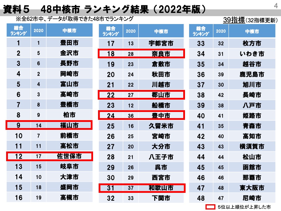
Travel through Japan's prefectural rail corridors and administrative classifications quickly lose their meaning. Shizuoka and Hamamatsu hold ordinance-designated status with populations surpassing 600,000, yet their downtown cores can feel surprisingly quiet after sunset. Meanwhile, stepping out of the train stations in Kanazawa, Utsunomiya, or Kagoshima reveals neon-lit commercial districts, humming light rail networks, and skyline density that rival major metropolitan zones. These powerhouses belong to Japan's core cities classification (chūkakushi), a secondary administrative tier that frequently punches well above its official weight.
The gap between nominal status and practical urban vitality has widened across Japan. While designated cities like Sapporo or Fukuoka dominate international headlines, a select group among the country's 62 core cities has engineered thriving downtown ecosystems. By pairing high commercial vitality indexes with strategic infrastructure investments, these regional anchors challenge conventional assumptions about Japanese urban hierarchy.
📌 Key Takeaways:
- The Administrative Divide: The population over 200,000 criteria grants local government administrative autonomy to core cities, but administrative tiers do not determine actual downtown density or nighttime energy.
- Autonomous Regional Dynasties: Independent prefectural capitals like Kanazawa, Kagoshima, and Matsuyama support far denser nightlife and shopping corridors than bedroom communities with larger total populations.
- Infrastructure-Led Resurgence: Transit systems like the Utsunomiya Light Rail and Toyama's compact city model have successfully decoupled regional urbanism from absolute population scale.
The Chūkakushi Threshold and the Illusion of Administrative Status
Japan established the core city framework under the Local Autonomy Law in 1995, later lowering the qualification threshold to an even 200,000 residents in 2015. The designation delegates key public health, environmental licensing, and urban planning powers from prefectures to local city halls. It was designed as an administrative efficiency measure, not a beauty contest for metropolitan prestige. Because of that distinction, population tallies alone offer a terrible proxy for how urban a Japanese city actually feels.
Consider the structural divide between suburban commuter bedroom towns and isolated regional capitals. A suburban core city in the Greater Tokyo area, such as Funabashi (pop. 647,000) or Kawaguchi (pop. 594,000), possesses raw demographic mass. Yet its commercial core often consists of little more than stacked shopping malls attached to a commuter rail terminal. Residents work, drink, and seek entertainment in Shinjuku or Tokyo Station. Their daytime-to-nighttime population ratios regularly plunge below 85%.
Independent regional hubs present the inverted dynamic. Prefectural seats situated hours away from the three major metropolitan areas of Tokyo, Osaka, and Nagoya must generate their own commercial pull. When an independent regional capital reaches a population of 400,000 to 500,000, it builds the department stores, corporate branch offices, transit loops, and entertainment quarters typical of a city twice its size. Measuring metropolitan character requires looking past raw headcounts to examine downtown pedestrian footfall, transit ridership, and architectural density.
Commercial Vitality and Skyline Density: Where Street Life Outpaces Population
Walk through the Katamachi and Korinbo districts of Kanazawa on a Friday evening. High-end department stores share street frontage with multi-story entertainment blocks, while narrow alleyways pack hundreds of bistros and bars into a tight, walkable grid. Kanazawa's population hovers around 458,000, yet its retail sales floor space per capita and concentration of financial institutions outshine several designated cities. The launch of the Hokuriku Shinkansen extension through Fukui in 2024 accelerated corporate investment, pulling regional headquarters into Kanazawa's central business district.
Farther south, Kagoshima exhibits an even sharper urban profile. Backed by the smoking caldera of Sakurajima, downtown Tenmonkan functions as Southern Kyushu's premier nightlife and retail district. With 589,000 residents, Kagoshima operates a municipal streetcar network carrying over 25,000 daily riders across two primary corridors. The district's covered shopping arcades span kilometers, anchoring a commercial engine that draws shoppers from across the entire Satsuma Peninsula. The skyline around Kagoshima-Chuo Station features high-density vertical development, high-rise hotels, and corporate offices that dwarf typical mid-sized cities.
In Shikoku, Matsuyama (pop. 505,000) dominates the island's economic landscape. Centered on the sprawling Okaido and Gintengai arcades, Matsuyama maintains an unbroken pedestrian commercial spine served by historic Iyotetsu trams. Its compact urban geography concentrates judicial, corporate, and leisure assets within a three-kilometer radius of Matsuyama Castle. In contrast to decentralized automobile suburbs, cities like Matsuyama preserve the continuous street-level activity that defines traditional Japanese metropolitan centers.
The 2026 Core City Urban Vitality Index: Data and Infrastructure Breakdown
Evaluating which core cities deliver the most convincing metropolitan experience requires synthesizing multiple urban variables. The comparison below weighs rail infrastructure, commercial concentration, and urban form across Japan's most prominent regional contenders.
| City & Prefecture | Population & Density | Transit Infrastructure | Commercial & Nightlife Hubs |
|---|---|---|---|
| Utsunomiya (Tochigi) | 513,000 / 1,230 per km² | Tohoku Shinkansen, Next-Gen LRT Network | Orion-dori Arcade, Higashiguchi Tech Corridor |
| Kanazawa (Ishikawa) | 458,000 / 980 per km² | Hokuriku Shinkansen, Central Loop Bus System | Katamachi, Korinbo, Omicho Market |
| Kagoshima (Kagoshima) | 589,000 / 1,075 per km² | Kyushu Shinkansen, Municipal Tram Network | Tenmonkan, Chuo Ekimae Commercial Zone |
| Matsuyama (Ehime) | 505,000 / 1,180 per km² | Iyotetsu Urban Trams, Suburban Railway | Okaido Arcade, Gintengai, Dogo District |
| Gifu (Gifu) | 398,000 / 1,960 per km² | JR Tokaido Line, Meitetsu Main Line Hub | Yanagase Arcade, Tamamiya Dining District |
| Toyama (Toyama) | 411,000 / 330 per km² (Core: 2,400) | Hokuriku Shinkansen, Integrated LRT Network | Sogawa Commercial Axis, Station Plaza |

Transit Innovation as an Urban Multiplier: The Utsunomiya and Toyama Playbooks
Automobile dependency hollowed out scores of provincial Japanese downtowns throughout the late 1990s and early 2000s. As big-box retailers colonised peripheral bypasses, historical station quarters withered. Two core cities broke that trajectory by prioritizing fixed-rail mass transit over road expansion.
Utsunomiya made history in August 2023 by opening the Utsunomiya Light Rail (LRT), Japan's first brand-new tram system in 75 years. Connecting the bustling eastern station plaza with the Haga industrial cluster over 14.6 kilometers, the line blew past early ridership forecasts, averaging over 16,000 passengers per day by early 2025. The transit corridor transformed Utsunomiya's physical profile. Sleek yellow-and-black low-floor trams sweep between mid-rise corporate buildings, linking high-tech manufacturers directly to bullet train connections to Tokyo.
With engineering now progressing on the LRT's western expansion through the historic Orion-dori arcade corridor toward Mount Oya, Utsunomiya has effectively reversed downtown flight. Private capital followed the tracks: new hotels, high-density residential towers, and co-working facilities rose around the stations within months of service launch.
Toyama executed a parallel urban pivot under its pioneering compact city policy. Facing steep population aging, city planners integrated fragmented railway corridors into the Toyama Light Rail network, connecting the northern port of Iwase directly across the Shinkansen tracks to southern residential suburbs. By offering municipal subsidies for high-density housing inside designated transit corridors, Toyama lifted core residential density above 2,400 residents per square kilometer. The Sogawa downtown district retained its department stores and independent retail because residents can access services without personal vehicles.
Tokyo Satellites Versus Independent Provincial Dynasties
A central debate on Japanese social forums centers on what defines tokaido (metropolitan atmosphere): raw density or functional independence? In Chiba and Saitama prefectures, cities like Funabashi, Kashiwa, and Kawagoe generate eye-watering pedestrian counts around their central railway gates. Funabashi Station processes roughly 130,000 JR passengers daily, creating a frenzy of movement that easily surpasses Kagoshima or Matsuyama.
Yet these satellite cities lack institutional depth. Their skylines feature apartment towers rather than corporate headquarters. Government branches reside elsewhere. Cultural institutions remain modest, because residents look to Tokyo for specialized healthcare, elite universities, and major concerts. They are high-density bedroom hubs rather than self-sustaining metropolitan worlds.
True regional powerhouses operate under opposing dynamics. Gifu, despite sitting just 20 minutes from Nagoya via JR rapid trains, maintains an independent commercial gravity. Its Tamamiya dining quarter houses over 400 establishments, sustained by local manufacturing wealth and Gifu University's student population. Kurashiki (pop. 470,000) in Okayama combines the Mizushima Industrial Complex, one of Japan's most productive petrochemical corridors, with the historic Bikan Quarter and dense retail districts. These independent hubs possess civic balance: residential housing, heavy industry, nightlife, and cultural assets existing in a single municipal boundary.
Livability Metrics: When Mid-Sized Scale Outperforms the Megacity
The post-pandemic shift toward remote and hybrid work prompted thousands of professionals to abandon Tokyo and Osaka. For these relocators, core cities sit in an ideal sweet spot on the livability index. They provide metropolitan infrastructure, high-speed internet, bullet train connectivity, specialty hospitals, and diverse dining, without the crushing rents and extreme transit congestion of the capital.
Real estate benchmarks underscore the economic contrast. In central Tokyo's Minato or Shibuya wards, average apartment rents routinely exceed ¥16,000 per tsubo (3.3 m²). In core city hubs like Kanazawa or Utsunomiya, equivalent modern housing rents for ¥6,500 to ¥8,000 per tsubo. Commercial office leasing tells a similar story, enabling startups and regional corporate branches to secure prime floor plates near bullet train terminals at fractions of Tokyo or Osaka rates.
The trade-offs remain real. Suburban bus frequencies drop sharply outside core rail corridors. Specialized English-language international schooling remains scarce outside major prefectural seats. Yet for daily life, core cities offer an urban efficiency that larger metropolises struggle to match. A ten-minute tram or bicycle ride connects quiet residential neighborhoods directly to central office towers, public parks, and dining districts.
Frequently Asked Questions (FAQ)
Q1: What is the official administrative difference between a core city and an ordinance-designated city?
A1: An ordinance-designated city (seirei shitei toshi) must have a population exceeding 500,000 (historically near 700,000) and receives nearly all administrative powers typically held by prefectures, including ward-level administration, social welfare, and urban highway management. A core city (chūkakushi) requires a population over 200,000 and handles delegated tasks like public health centers, environmental management, and local urban zoning, while leaving broader regional infrastructure to the prefecture.
Q2: Why do some core cities feel more urban than designated cities like Shizuoka or Kitakyushu?
A2: Urban atmosphere depends on geographic compactness, historical capital status, and transit layouts rather than legal designation. Several designated cities were formed by merging widespread towns or have decentralized downtown districts. In contrast, isolated core cities like Kagoshima, Matsuyama, or Kanazawa concentrate commercial activity, entertainment, and administrative buildings within a single walking-and-transit corridor, producing much higher street-level vitality.
Q3: Which Japanese core city has experienced the fastest commercial revitalization?
A3: Utsunomiya holds that distinction following the 2023 launch of its Light Rail Transit (LRT) system. The new line catalyzed over ¥30 billion in private hotel, retail, and office investments around Utsunomiya Station, boosting central pedestrian counts and demonstrating how modern transit investments can rapidly revitalize regional city centers.
Navigating Japan’s Shifting Regional Hierarchies
Japan's ongoing demographic contraction is rapidly dismantling the old logic that equated population size with economic strength. Over the coming decade, cities that sprawl without purpose will see their tax bases crumble and municipal services decline, regardless of their official administrative designations. The regional hubs poised to thrive are those actively shaping dense, connected downtowns.
The standout performers among Japan's 62 core cities reveal what sustainable urbanism looks like outside the mega-regions. Kanazawa leverages cultural heritage and high-speed rail. Utsunomiya and Toyama demonstrate the power of fixed-track public transit. Kagoshima and Matsuyama prove that independent regional capital status can sustain vibrant, walkable urban centers indefinitely. For real estate investors, business operators, and prospective residents seeking urban energy without the friction of megacities, these dynamic regional hubs offer compelling proof that scale is no substitute for smart design.